A Little Hiking in Colorado
A friend from work and I departed Austin for Denver Friday afternoon, May 30. Our original plan was to hike primarily in Rocky Mountain National Park. But it was a little early in the season for many hikes there. We had called the park ranger the week before, and they warned us that many of the hikes were “slushy”.
So, I brought along my book Hiking Colorado’s Front Range and my trusty Trails Illustrated Trail Map for Boulder and Golden for drier hiking ideas.
Day 1: Heil Valley Ranch
Our warmup hike was in a Boulder County park called Heil Valley Ranch. It was a little over 7.5 miles, with elevation of 5900′ to 6800′.
This hike was pretty uneventful. The trail is used by a lot of mountain bikes. On the return leg, we were warned of a rattlesnake that we never saw. There were some nice wildflowers.

And here’s an infrared shot from my converted Nikon D200 camera…
Day 1: Boulder Falls
After this hike, we made a quick trip up Boulder Canyon and visited Boulder Falls…
And then we kept a mid-afternoon lunch date with an old friend at Tahona Tequila Bistro on Pearl Street in downtown Boulder.
After our late lunch, we continued walking down Pearl Street. This pedestrian mall has a lot of street performers, and we stopped to listen to a country trio. I thought they were really good—they had a good “presence”, and the lead singer had a great voice. She kind of had the style of Iris Dement. I bought a CD from them. Later, I checked out the band’s website, only to discover that they were an Austin band on tour. The band is Shotgun Party (on MySpace).
After this leisurely afternoon, we went up to the National Park to check out the situation there…
There was plenty of snow above 9000′ in the middle of the park, but it looked like we could still hike some places inside the park.
Day 2: Button Rock Preserve
On Sunday, we decided to do a couple of hikes, starting with a relatively “easy” hike near Button Rock Reservoir.
This 4.5 mile hike starts out on a gravel road at about 6000′, but moves on to a somewhat more difficult trail after about a mile.
In this photo, you can see my friend and his red daypack hiking off into the distance. This was a common occurrence, because he is in better shape than I am and dealt with the altitude better than me.
Here’s another infrared shot from the hike…
Day 2: Gem Lake Trail
Next, we drove up through Estes Park to the Lumpy Ridge Trailhead to hike to Gem Lake. This is a short hike of a little more than 3 miles, but the elevation nears 9000′ at Gem Lake.
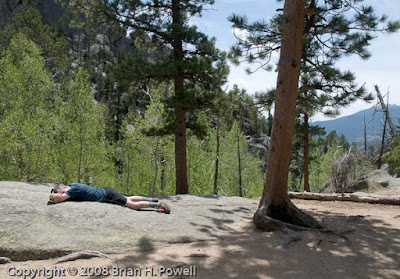
Here’s what happens when my friend got really far ahead of me. He just lays down and takes a nap…
Eventually, he managed to drag me all the way to the lake and wait patiently for me to take pictures…

Here’s another infrared shot of the lake…
And on the way down, I stop for a nice view of Estes Park…

Day 2: Trail Ridge Road
After the hike, my friend wanted to drive to the western side of the park over Trail Ridge Road. I’m a little skeptical, because it’s already mid-afternoon, but what the heck, it’s only about 150 miles to take the long way back to Boulder, and he’s paying for half the gas.
Here are a few more pictures from the trip up. Here’s a picture of the Alluvial Fan, created by the Lawn Lake flood of 1982.
And here’s an overall panorama from about the same point on the road…

And a bird hanging out at 10,000′ or so…
Day 3: Bear Peak
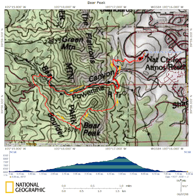
The big hike of the weekend was Bear Peak, just southwest of Boulder—almost 8 miles, starting at about 6000′, and reaching the Bear Peak summit above 8400′.
The hike starts at the National Center for Atmospheric Research, up Bear Canyon to the western ridge of Bear Peak. There are some nice views of the flatirons from there…

We took a shorter, but steeper route down through Fern Canyon. This return route was miserably steep—downhill, but very slow going because of the rocky terrain and because my knees were getting tired.
Fortunately, I had a one-hour head start on my friend. He stopped on the way up for a work-related conference call. He had to find a spot with a view towards Boulder to get cell phone coverage. Here’s the approximate location, looking down on the NCAR buildings…
While he was on the phone, I trudged ahead as the trail got steeper near the summit. The plan was for me to wait at the summit, but the bugs were too annoying there.
After descending a few hundred feet, I stopped and made my own work-related phone call. After I hung up, I decided to keep descending (and descending and descending). My friend didn’t catch up with me until the last couple of miles.
After our return to NCAR, my friend made a great suggestion to eat a late lunch at the Chautauqua Dining Hall in Boulder.


