Skip to content

Posts tagged ‘Colorado’

Maroon Bells Recreation Area

This past week, I had a chance to go up to Aspen, Colorado, and visit the Maroon Bells Recreation Area in the White River National Forest.  There had been rain all over Colorado—major flooding near Boulder, Lyons, and Estes Park—so, I stayed further south and west by visiting Aspen.  There was a mix of sun and clouds as I started hiking past Maroon Lake.

The Aspen trees are just beginning to turn to their bright yellow fall colors, and soon, this area will be inundated with photographers.  I was told it is the most photographed spot in Colorado.  Always wanting to do something a little bit different, I used my infrared camera (a Nikon D200, converted by LifePixel) to capture the image below.

By the end of my hike, the storm clouds had started to surround the peaks, light rain and thunder started, and I made it back to my car just in time.  It was a great hike.

_DSC0184

Click to enlarge.

Rainbow Lakes, Colorado

I was in Colorado last week, and got a chance to do a short hike to the Rainbow Lakes (elevation, approximately 10,000 ft.), north of Nederland and west of Boulder.  The temperature was perfect, with a gentle rain occasionally falling.

rainbowlakes

Here’s a photo of a late-in-the-season Arapaho Glacier, from one of the upper Rainbow Lakes.

_DSC1072

On my drive up County Road 116 (Rainbow Lakes Road), I turned a corner to find a moose standing in the road.  We shared a mutual look of surprise before he walked off into the woods.

_DSC1070

The fall colors along the Peak to Peak Highway north of Nederland were gorgeous.

_DSC1045

I love September in Colorado.  But I love every month of the year in Colorado—being with friends and enjoying the mountains.

August in Colorado

I was in Denver again this past week for work, and visiting friends.

And seeing a Rockies baseball game.

And seeing the Goo Goo Dolls concert at the Red Rocks Amphitheater.  (Wow, that’s an awesome place!)

I also had a chance to do a little hiking.  I borrowed a friend’s copy of the book Hiking Colorado’s Front Range, and selected a hike around Mount Galbraith, near Golden.

Here’s the GPS track from my hike. I used the new Garmin GPSMAP 62s, which I really like.

Mt Galbraith Topo Map

And an infrared photo, looking off to the southwest…

20100828_0005 Thanks again to all my friends from Colorado, and my friends from Austin who were up there with me.

Denver

This past weekend, I was in Denver visiting friends and attending a couple of parties.

On Friday, I went to Roxborough State Park, southwest of Denver.

roxboroughmap

Roxborough is a pretty park, with some nice red rocks.  I’d been to Roxborough a few years ago, spending a few hours with John Fielder, a well-known Colorado photographer.  At the suggestion of the park ranger at the front gate, I hiked the South Rim trail, which I had not hiked before.  This was an excellent choice, with good views of the rock formations in the middle of the park.

RoxboroughClick to Enlarge

I was also in town to attend the opening reception for a show entitled “Sense of Place | Landscape Photography”, at the FLASH Gallery in Lakewood, Colorado.  One of my Bosque del Apache photographs is in the show, which runs June 11 through August 1, 2010.

I was honored that about twenty of my friends from the Denver area made it to the opening reception.  Thanks to all of you who made it out on a rainy night.  Here I am at the gallery with one of my best friends, Nancy.

Brian_Nancy

I enjoyed the whole weekend, including the cool weather, and hope I’m back soon.

Exhibit of Landscape Photography in Colorado

Ongoing exhibit: Sense of Place | Landscape Photography, at the FLASH Gallery in Lakewood, Colorado. One of my Bosque del Apache photographs is in the show, which runs June 11 through August 1, 2010.

I had about twenty friends from the Denver area who made it to the opening reception. Thanks to all of you who made it out on a rainy night. Here I am at the gallery with one of my best friends, Nancy.

20100611_0075

A Weekend in Denver

After leaving New Mexico, I went up to Colorado and enjoyed catching up with several friends. My first night, I captured this great sunset with the Denver skyline from my hotel room balcony.

Denver_Sunset

My friend Micaela took me snowshoeing for the first time.  We went up to Bear Lake, in Rocky Mountain National Park, and we had a wonderful time with a couple of feet of fresh powder in some places.

Snowshoeing in RMNP Despite her best efforts with snowballs, she did not cause me to trip over my own snowshoes and fall down.

Fall Color in Colorado

AspensClick Images to Enlarge

I’ve just returned from a week in Colorado.

I enjoyed…

  • visiting great friends,
  • great weather,
  • the peak of fall color of the aspens.

A mountainside of beautiful fall color is a wonderful thing, but my “traditional portraits” of the aspens just weren’t exciting me.

So my friend Micaela and I walked into the forest a few yards.  I aimed the camera up.  And down.  I slowed the shutter speed.  I overexposed.  I underexposed.  I twisted the camera during the exposures.

I was having fun with my camera. And I finally felt creative. Let me know what you think.

Aspen Leaves on the Forest Floor

 Aspens and Clouds

A Little Hiking in Colorado

A friend from work and I departed Austin for Denver Friday afternoon, May 30. Our original plan was to hike primarily in Rocky Mountain National Park. But it was a little early in the season for many hikes there. We had called the park ranger the week before, and they warned us that many of the hikes were “slushy”.

So, I brought along my book Hiking Colorado’s Front Range and my trusty Trails Illustrated Trail Map for Boulder and Golden for drier hiking ideas.

Day 1: Heil Valley Ranch
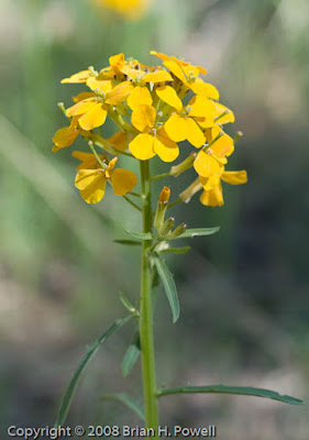
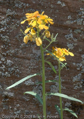
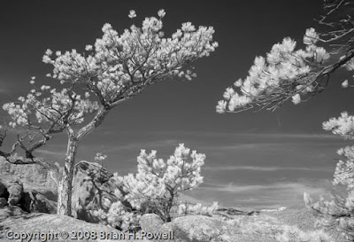
Our warmup hike was in a Boulder County park called Heil Valley Ranch. It was a little over 7.5 miles, with elevation of 5900′ to 6800′.

This hike was pretty uneventful. The trail is used by a lot of mountain bikes. On the return leg, we were warned of a rattlesnake that we never saw. There were some nice wildflowers.


And here’s an infrared shot from my converted Nikon D200 camera…

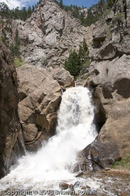
Day 1: Boulder Falls
After this hike, we made a quick trip up Boulder Canyon and visited Boulder Falls…

And then we kept a mid-afternoon lunch date with an old friend at Tahona Tequila Bistro on Pearl Street in downtown Boulder.

After our late lunch, we continued walking down Pearl Street. This pedestrian mall has a lot of street performers, and we stopped to listen to a country trio. I thought they were really good—they had a good “presence”, and the lead singer had a great voice. She kind of had the style of Iris Dement. I bought a CD from them. Later, I checked out the band’s website, only to discover that they were an Austin band on tour. The band is Shotgun Party (on MySpace).

After this leisurely afternoon, we went up to the National Park to check out the situation there…

There was plenty of snow above 9000′ in the middle of the park, but it looked like we could still hike some places inside the park.

Day 2: Button Rock Preserve
On Sunday, we decided to do a couple of hikes, starting with a relatively “easy” hike near Button Rock Reservoir.

This 4.5 mile hike starts out on a gravel road at about 6000′, but moves on to a somewhat more difficult trail after about a mile.

In this photo, you can see my friend and his red daypack hiking off into the distance. This was a common occurrence, because he is in better shape than I am and dealt with the altitude better than me.

Here’s another infrared shot from the hike…

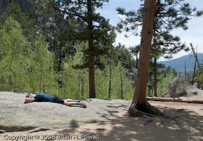
Day 2: Gem Lake Trail
Next, we drove up through Estes Park to the Lumpy Ridge Trailhead to hike to Gem Lake. This is a short hike of a little more than 3 miles, but the elevation nears 9000′ at Gem Lake.

Here’s what happens when my friend got really far ahead of me. He just lays down and takes a nap…

Eventually, he managed to drag me all the way to the lake and wait patiently for me to take pictures…

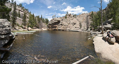
Here’s another infrared shot of the lake…

And on the way down, I stop for a nice view of Estes Park…


Day 2: Trail Ridge Road
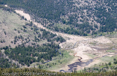
After the hike, my friend wanted to drive to the western side of the park over Trail Ridge Road. I’m a little skeptical, because it’s already mid-afternoon, but what the heck, it’s only about 150 miles to take the long way back to Boulder, and he’s paying for half the gas.

Here are a few more pictures from the trip up. Here’s a picture of the Alluvial Fan, created by the Lawn Lake flood of 1982.

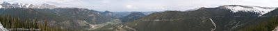
And here’s an overall panorama from about the same point on the road…

And a bird hanging out at 10,000′ or so…

Day 3: Bear Peak
The big hike of the weekend was Bear Peak, just southwest of Boulder—almost 8 miles, starting at about 6000′, and reaching the Bear Peak summit above 8400′.

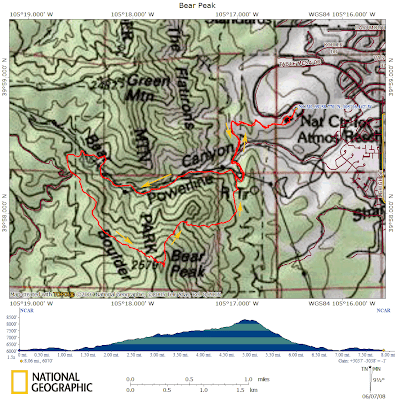
The hike starts at the National Center for Atmospheric Research, up Bear Canyon to the western ridge of Bear Peak. There are some nice views of the flatirons from there…


We took a shorter, but steeper route down through Fern Canyon. This return route was miserably steep—downhill, but very slow going because of the rocky terrain and because my knees were getting tired.

Fortunately, I had a one-hour head start on my friend. He stopped on the way up for a work-related conference call. He had to find a spot with a view towards Boulder to get cell phone coverage. Here’s the approximate location, looking down on the NCAR buildings…

While he was on the phone, I trudged ahead as the trail got steeper near the summit. The plan was for me to wait at the summit, but the bugs were too annoying there.

After descending a few hundred feet, I stopped and made my own work-related phone call. After I hung up, I decided to keep descending (and descending and descending). My friend didn’t catch up with me until the last couple of miles.

After our return to NCAR, my friend made a great suggestion to eat a late lunch at the Chautauqua Dining Hall in Boulder.